Research Results
Dissertations, articles, datasets, and infrastructure improvement reports
Publications about dataARC
Alexander, S. M., Jones, K., Bennett, N. J., Budden, A., Cox, M., Crosas, M., ... Strawhacker, C.& Karcher, S. (2019). Qualitative data sharing and synthesis for sustainability science. Nature Sustainability, 1-8.
Buckland, P.I. & Sjölander, M. (2020). Approaches to Research Data Infrastructure for Archaeological Science.. Digital Heritage and Archaeology in Practice. Watrall, E. & Goldstein, L.. University Press Florida.. .
Palsson, G. and Opitz, R. (2019) DataArc: a case study using CIDOC CRM as an ontology for transdisciplinary research. In Niccolucci, F. and Richards, J. (2019) The ARIADNE Impact, ARCHAEOLINGUA FOUNDATION, Hungary. Publication link
Jones, K., Alexander, S. M., Bennett, N., Bishop, L., Budden, A., Cox, M., Strawhacker, C.... & Hardy, D. (2018). Qualitative data sharing and re-use for socio-environmental systems research: A synthesis of opportunities, challenges, resources and approaches. Publication link
Strawhacker, C., Buckland, P., Palsson, G., Fridrikkson, A., Lethbridge, E., Brin, A., ... & Dawson, T. (2015). Building cyberinfrastructure from the ground up for the North Atlantic Biocultural Organization introducing the cyberNABO Project. In 2015 Digital Heritage (Vol. 2, pp. 457-460). IEEE.
Presentations/Posters about dataARC
Opitz, R., Strawhacker C., Buckland, P.I., Palsson, G., Pulsifer, P., Yarmey, L., Lethbridge, E., Mainland, I., Newton, A., Streeter, R., Dawson, T. and Cothren, J. (2018) Driving interdisciplinary search for collaborative studies of long-term human ecodynamics. Computer Applications & Quantitative Methods in Archaeology Conference. Tübingen, Germany. March 19-23. Presentation Link
Strawhacker C., Opitz, R., Brin, A., Buckland, P.I., Palsson, G., Lethbridge, E., Mainland, I., Newton, A., Yarmey, L., Streeter, R., Dawson, T. Cothren, J., and Pulsifer, P. (2018) Driving interdisciplinary search and discovery for collaborative studies of long-term human ecodynamics. Society for American Archaeology Conference. Washington DC. April 11-15.
Palsson, G., Opitz, R., Strawhacker C., and Brin,A. (2017). Driftwood, power and ecclesiastical spacetime volumes: CIDOC-CRM and the complexity of archaeo-historical concepts. European Association of Archaeologists Conference. Maastricht, Netherlands. August 30 – September 3. Presentation Link
Buckland, P.I. & Sjölander, M. (2017). A Prototype System for Massively Interdisciplinary Data-Linking. Computer Applications & Quantitative Methods in Archaeology Conference. Atlanta, Georgia. March 14-16. Presentation Link
Opitz, R., Strawhacker C., Brin, A. Palsson, G., Lethbridge, E., Buckland, P.I., Pulsifer, P., Cothren, J., and McGovern, T.H. (2017). Linking International and Interdisciplinary Data to Enable Data- Intensive Research on Long-Term Human Ecodynamics in the North Atlantic: the DataARC Project. Grand Challenge Agendas in Environmental Archaeology. University of Edinburgh. December 1-3. Presentation Link
Strawhacker C., Opitz, R., Brin, A., Buckland, P.I., Palsson, G., Dawson, T., Mainland, I., Newton, Streeter, R., and Cothren, J. (2017) Linking International and Interdisciplinary Data to Enable Synthesis Research in the North Atlantic: The dataARC Project. European Association of Archaeologists Conference. Maastricht, Netherlands. August 30 – September 3. Presentation Link
Buckland, P.I. & Sjölander, M. (2017). Strategic Environmental Archaeology Database (SEAD) – Visualizing and exploring the data on past landscapes. International Conference on Management, Leadership and Social Science (ICASS-MLS 2017). Moscow, Russia. June 28 – 29. Presentation Link
POSTERS
Newton, A., Dugmore, A. Huminyik, O., Opitz, R., Palsson, G., and Streeter, R. (2019). Integrating tephrochronology with environmental and historical data: Tephrabase and dataARC. 20th Congress of the International Union for Quaternary Research (INQUA). Dublin, Ireland. July 25 – 31. Poster Link
Newton, A., Streeter, R., Strawhacker, C., Brin,A., Opitz,R., Buckland, P.I., Dugmore, A., and McGovern, T.H. (2018) Integrating tephrochronology with archaeology, the humanities, and palaeoenvironmental and palaeoclimatic records (dataARC). INTAV inter-congress meeting. Brasov, Romania. June 24 - 29. Poster Link

Completed master's dissertation supported by the dataARC project.
Kaja Ronning - Archaeology, Environment and Human History: Examining the Spatial Links Between Human Settlements and Environmental Change in Iceland. University of Edinburgh.
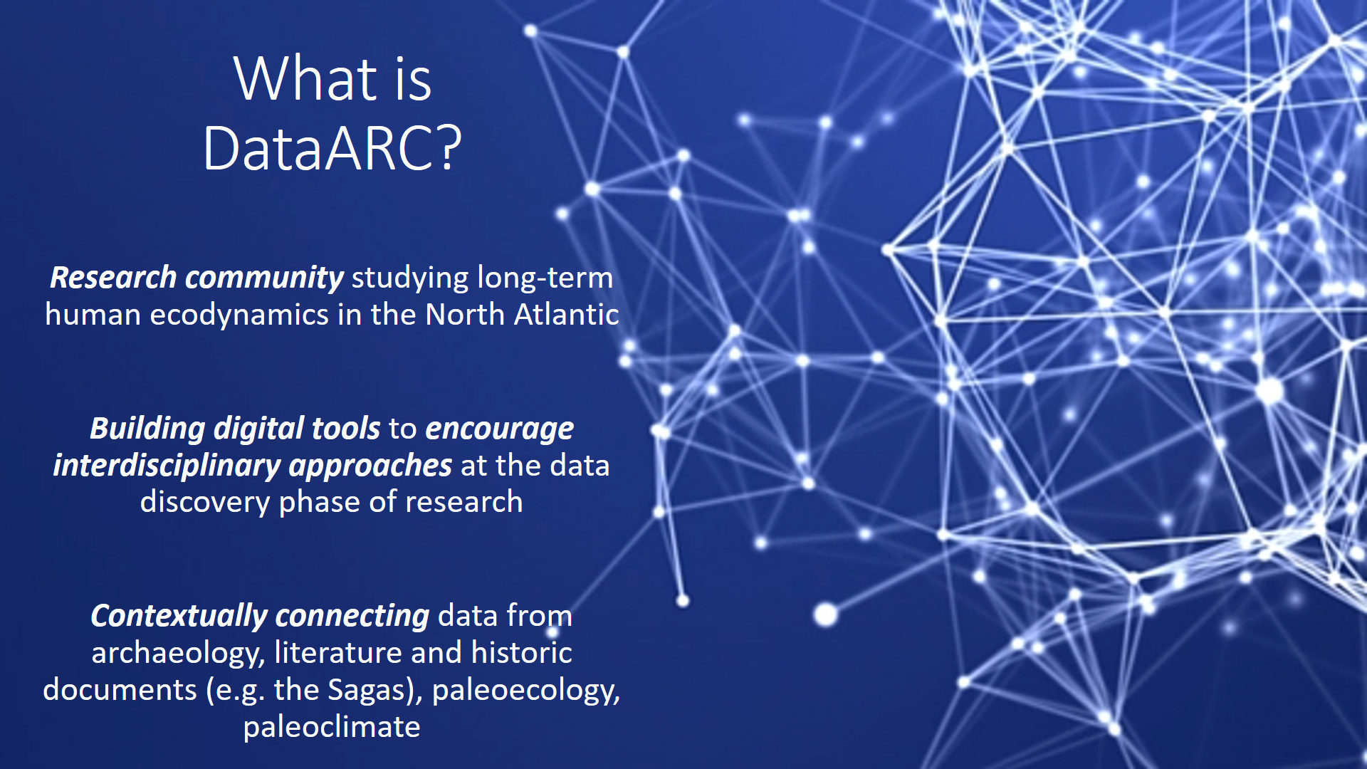
Research on how humans have interacted with a changing environment over time requires linking complex data and information from a range of disciplines and contextualize it in both time and space. In recent years such interdisciplinary research has become increasingly more frequent as a way of unveiling hidden patterns between data from a wide range of subjects. One such research initiative is dataARC, whose objective is to enable studies of human ecodynamics around the North Atlantic during the middle ages, using both archaeological, environmental, and historical data.
This paper describes a project developed within the wider framework of dataARC and aims to help bridge the gap between research from multiple disciplines in a spatial context by implementing a multi-dimensional approach and produce a visualizing tool that effectively combines cross-disciplinary datasets and appropriately map their connections in geographic space.
The study focuses on investigating spatial connections between literary, environmental, and zooarchaeological data from Iceland, in order to create a visualization prototype that can be implemented into the continuing work of dataARC. Using Self-Organising Maps (SOM), an unsupervised clustering technique, the study explores methods synthesizing this information by identifying 10 cluster profiles with specific signatures related to the combination of sets of attributes or indicators. This analysis makes clear the considerable potential of a SOM approach in advancing pattern recognition between cross-disciplinary data.
Access the full publication, including jupyter notebook scripts, here.
Access the SOM datasets here.


Completed master's dissertation supported by the dataARC project.
Pablo Barruezo Vaquero - Exploring the ontological links between Human Ecodynamics and field Archaeology through the integration of archaeological reports into DataARC's landscape ontology. University of Glasgow.
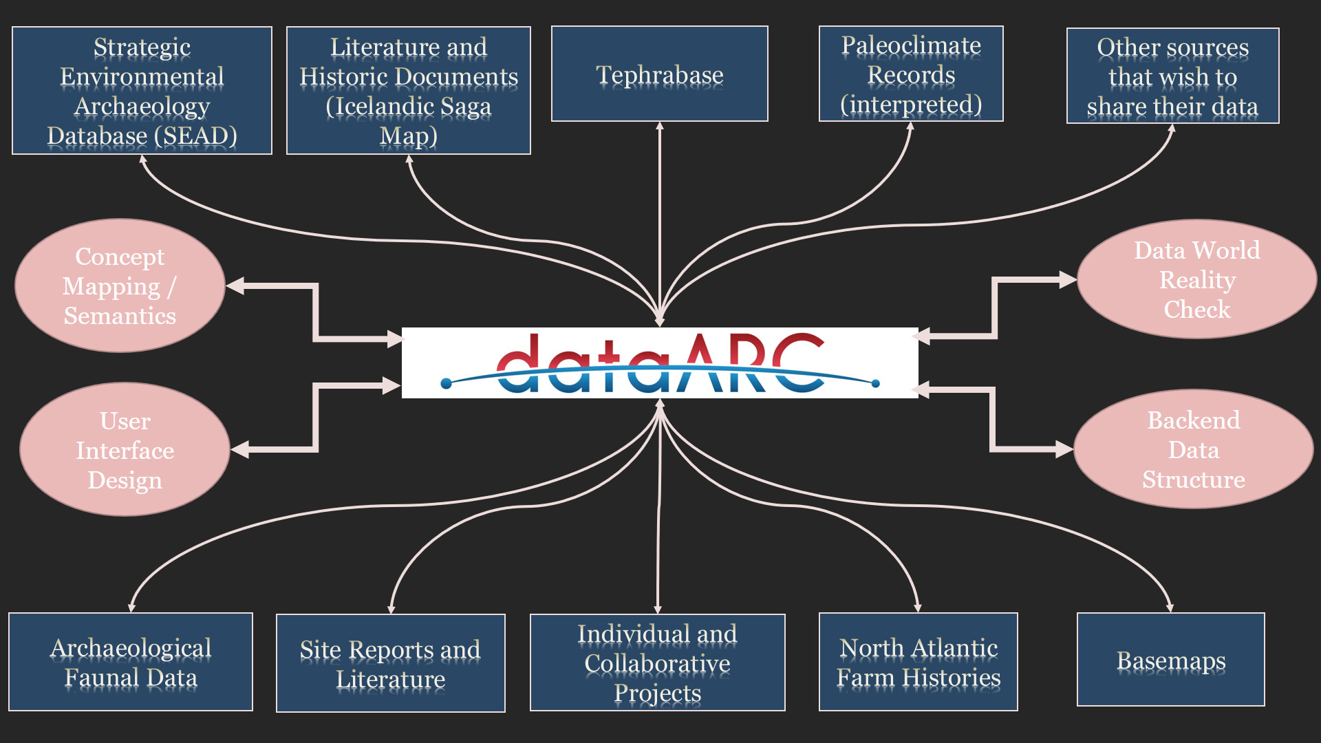
This research focuses on the processes of knowledge creation within a framework of Big Data. Concretely, my project focus on grey archaeological data and their underlying ontologies, and how to interlink such type of data with other data in a Computational Ontology. This research was carried out within the dataARC Project, which tries to represent Human Ecodynamics for the North Atlantic context using data generated over 25 years by NABO (North Atlantic Biocultural Organisation). The project has been developing a cyberinfrastructure whose main tool is a computational ontology. We try to include in this ontology diverse conceptual models (from archaeological and historical, to ecological or geological data) from different grey sources.
In my case, the main issue is the creation of knowledge using multiple datasets that comes from grey literature sources. Said another way, my thesis explores how to create a dataset by extracting data and their underlying ontologies from grey-archaeological reports with the final aim of interlinking them with other datasets. For so doing, these reports are transformed into a dataset, which in turn is mapped to the interdisciplinary ontology. This thesis, therefore, presents a prototype dataset and the process of conceptual mappings. In so doing, I explore how to decompose archaeological reports that are in Open Access to make their data FAIRer and (inter)linked.
Access the full publication here.
Completed master's dissertation supported by the dataARC project.
Mar Roigé Oliver - Cairn and Landscape Interaction. A Study of Human Ecodynamics in the North Atlantic. University of Glasgow.
Cairns are very versatile constructions, used for a variety of human activities. For this reason, this master’s thesis focuses on the analysis of navigational and agricultural cairns as a way to further the study and understanding of human ecodynamics in the North Atlantic. The project was developed within the wider framework of dataARC, a cyberinfrastructure that interconnects several North Atlantic datasets while facilitating access to them. This master’s thesis aims to connect its results and datasets to cyberinfrastructure’s concept map. The study uses a variety of interdisciplinary data, methodologies, tools, and approaches in its analysis. It is divided into two case studies.
Case Study One analyses the role of navigational cairns and their relationship with the roads and the general landscape while creating proposed routes between late medieval/early modern farm networks in Iceland. The methods used in this case study are least-cost path and intervisibility analysis. The results support the hypothesis that cairns were being used as road markers, and suggests a dependence between landscape features and cairn positioning, indicating landscape agency.
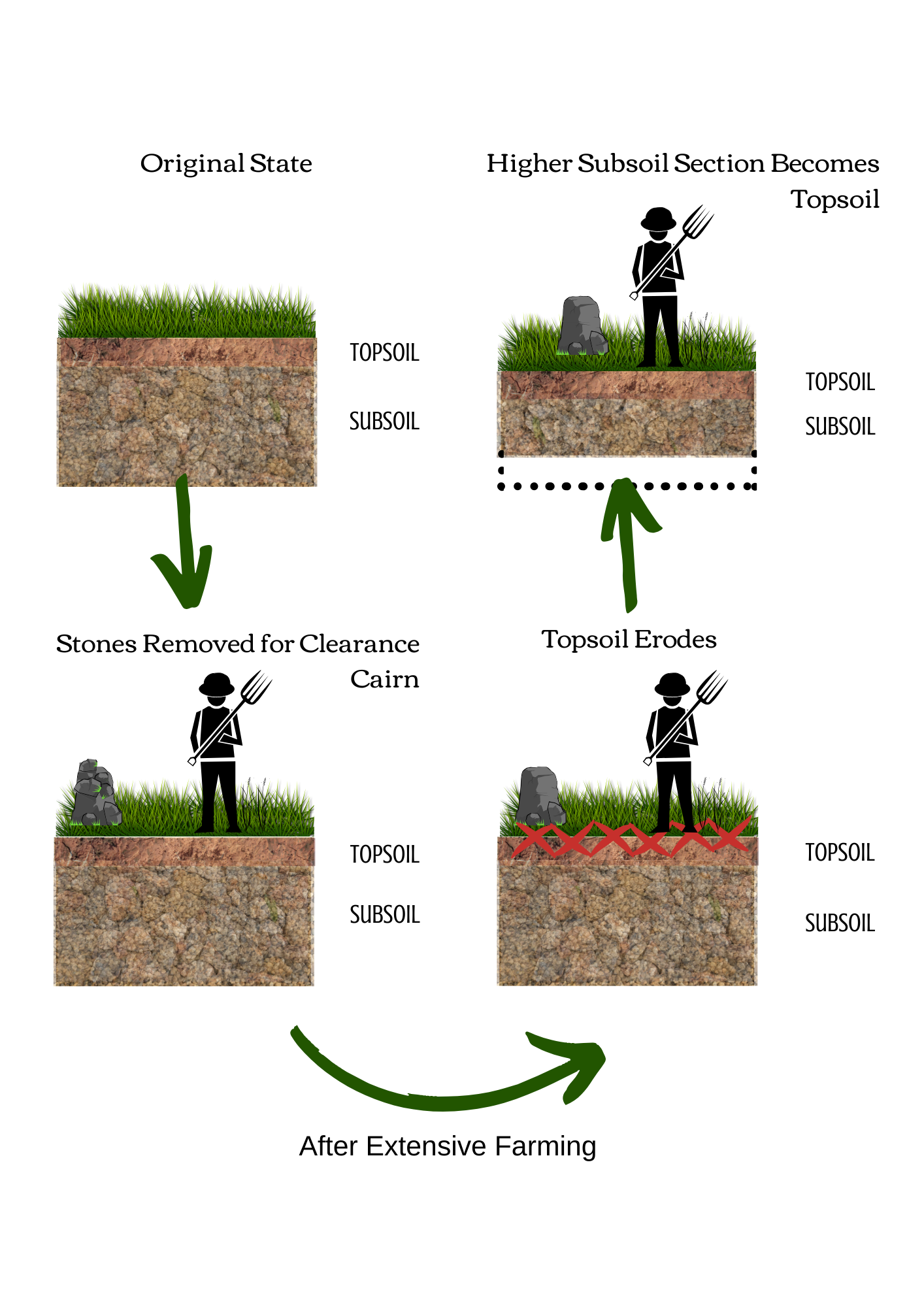
Case Study Two focuses on analyzing the position and effect of clearance cairns in the Scottish landscape. Archaeological and landscape data (i.e. soil quality, land compaction, erosion levels, and continued use in agricultural practices) were combined in a newly created dataset that was examined with statistical analysis.
The results show a correlation between the presence of cairns and a high erosion risk while proposing three effects of clearance cairns on soils: so exhaustive they are no longer cultivable, they are cultivable but have a risk of erosion, and so non-exhaustive that they can still be cultivated. Overall, the project’s findings highlight cairns’ usefulness in the study of human ecodynamics. In both case studies, cairns are the physical representation of an active and ever-changing interaction between humans and their environment, and the relevance and agency of landscape. These are based on Case Study One’s feature-dependent cairns, and Case Study Two’s observation of human adaptation to the landscape’s changes. This opens the possibility of an expansion of the area of study, including other areas and continents, and/or a focus on developing studies that focus on cairn multifunctionality.
Access the data archive on zenodo.
Publications describing related datasets and data infrastructures where improvements were enabled through dataARC
Buckland, P.I., Sjölander, M. & Eriksson, E.J. (2019). Strategic Environmental Archaeology Database (SEAD). The Encyclopedia of Global Archaeology Springer.
Dugmore, A., Jackson, R. Cooper, D., Newton, A., J Júlíusson, A.D., Streeter, R., Hreinsson, V., Crabtree, S., Hambrecht, Hicks, M., and McGovern, T.H. (2020). Continuity in the face of a slowly unfolding catastrophe: the persistence of Icelandic settlement despite large-scale soil erosion. Catastrophes in Context Felix Riede and Payson Sheets. Bergham Books. Oxford.
Lethbridge, E. and Hartman, S.. (2016). Inscribing Environmental Memory in the Icelandic Sagas (IEM) and the Icelandic Saga Map (ISM) Project. Publications of the Modern Language Association of America. 131 381-391.
Lethbridge, E. (2020). Digital Mapping and the Narrative Stratigraphy of Iceland. In Historical Geography, GIScience and Textual Analysis (pp. 19-32). Springer, Cham.
McGovern, T. (2018). What Is It All For? Archaeology And Global Change Research. SAA Archaeological Record. 18 (5) .
Pálsson, G. (2019). Domination, subsistence, and interdependence: Tracing resource claim networks across Iceland’s post-reformation landscape. Human Ecology, 47(4), 619-636.
Report on preparation of the NABONOSEAD data
In order to modernize and upgrade the NABONE Zooarchaeological Database (also referred to as the NABONE Zooarchaeological Analysis Package), the decision was made to migrate all existing data into the Strategic Environmental Archaeological Database (SEAD) and provide for ongoing data entry into the SEAD system. The aims of the NABONOSEAD project are to deliver sustainable upscaling of the Access zooarchaeological database, open access to the data online and through an API, and efficient and portable data storage. This report describes the work undertaken and highlights key challenges and areas for future work.
This report was prepared by Tom Ryan (CUNY).
Student Project: Mapping degrees of connectivity across the DataArc concept map
The Data Network Overview Analyses tool is available as a Jupyter notebook and is part of the dataARC Ecosystem Explorer. This notebook allows users to calculate graph metrics such as betweenness centrality on the dataARC concept map. The notebook provides a useful starting point for a high-level exploration of how connected different concepts are. The queries in this notebook run off the API and provide an example of how jupyter notebooks can be used to explore the data and concepts linked through DataArc.